
 Continue with onX Maps
 Continue with Facebook


 Particularly Special Place


 Intermediate
Intermediate
Intermediate
 Intermediate
 Lewis Trail
7.7 mi 12.5 km • 751' Up 229.04 m Up • 784' Down 239.1 m Down

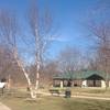
 Weldon…, MO
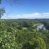
 Castlewood State Park Loop
2.3 mi 3.7 km • 327' Up 99.66 m Up • 327' Down 99.53 m Down
 Dames Park Figure 8
1.2 mi 1.9 km • 29' Up 8.89 m Up • 29' Down 8.72 m Down
Lakeside Park
4.5 mi 7.3 km • 17' Up 5.12 m Up • 17' Down 5.27 m Down
Western Pool Loop
6.5 mi 10.5 km • 52' Up 15.85 m Up • 52' Down 15.84 m Down
 Dresser Island Levee Trail
5.7 mi 9.1 km • 142' Up 43.14 m Up • 140' Down 42.74 m Down


 All Clear


0 Comments