
 Continue with onX Maps
 Continue with Facebook


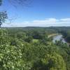
 Particularly Special Place


 Intermediate
Intermediate
Intermediate
 Intermediate
Land Manager: Missouri Department of Conservation
 Ozark Foothills 25k
15.9 mi 25.5 km • 1,483' Up 452.03 m Up • 1,461' Down 445.46 m Down

 Wildwood, MO
 Turtle Bob's Trail
0.9 mi 1.4 km • 110' Up 33.58 m Up • 113' Down 34.39 m Down
Meramec River Out-and-Back
0.8 mi 1.2 km • 105' Up 31.95 m Up • 105' Down 31.89 m Down
Castlewood State Park Loop
2.3 mi 3.7 km • 327' Up 99.66 m Up • 327' Down 99.53 m Down
Lewis Trail
7.7 mi 12.5 km • 751' Up 229.04 m Up • 784' Down 239.1 m Down
Weldon…, MO
Jack's Loop
4.1 mi 6.5 km • 394' Up 119.98 m Up • 394' Down 119.96 m Down


 Minor Issues


0 Comments