Continue with onX Maps
 Sign in with Facebook


Gifford Pinchot National Forest
 WA
WA- Southwest Washington
- Gifford Pinchot National Forest


Gems in Gifford Pinchot National Forest - 3
Trail Run Project is built by runners like you. Add Your Gems


Recommended Routes in Gifford Pinchot National Forest - 10
Trail Run Project is built by runners like you. Add Your Recommended Routes


 Difficult
Mount St. Helens Summer Climbing Route: Monitor Ridge
8.8 mi 14.1 km • 4,489' Up 1368.15 m Up • 4,488' Down 1368.04 m Down

 Amboy, WA
Difficult
Amboy, WA
Difficult
Mount St. Helens Winter Route: Worm Flows
10.5 mi 17.0 km • 5,600' Up 1706.76 m Up • 5,599' Down 1706.67 m Down
Amboy, WA
 Difficult
Mount Adams South Climb (Lunch Counter Approach)
11.8 mi 18.9 km • 6,687' Up 2038.12 m Up • 6,686' Down 2037.97 m Down
White S…, WA

 Intermediate/Difficult
Snowgrass Flats Loop
15.0 mi 24.1 km • 2,978' Up 907.84 m Up • 2,988' Down 910.6 m Down
Morton, WA
 Difficult
Loowit Loop
29.4 mi 47.4 km • 5,697' Up 1736.3 m Up • 5,696' Down 1736.19 m Down
Amboy, WA

 Intermediate
Packwood Lake
8.5 mi 13.7 km • 681' Up 207.53 m Up • 680' Down 207.36 m Down
Morton, WA

 Easy/Intermediate
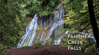
Panther Creek Falls Trail #137
0.6 mi 1.0 km • 87' Up 26.41 m Up • 86' Down 26.32 m Down
Carson, WA
 Intermediate
Trapper Creek Out-and-Back
7.6 mi 12.3 km • 1,704' Up 519.52 m Up • 1,704' Down 519.49 m Down
Stevenson, WA


Gifford Pinchot National Forest Running
- 875 Miles 1,409 Kilometers of Trail
- 10 Recommended Routes
- 3 Gems

- 96
Easy Trails

- 124
Intermediate Trails

- 93
Difficult Trails

Areas Within Gifford Pinchot National Forest
Weather Averages
|
High
|
Low
|
Precip
|
Days w/
|
| J | F | M | A | M | J | J | A | S | O | N | D |
Trails in Gifford Pinchot National Forest - 303
Trail Run Project is built by runners like you. Add Your Trails
|
4.1
mi
6.7
km
#1Nannie Ridge Trail
Intermediate/Difficult
Morton, WA
|
Intermediate/Difficult
|
Morton, WA |
4
|
|
|
0.4
mi
0.6
km
#2Lower Lewis River Falls
Easy/Intermediate
Stevenson, WA
|
Easy/Intermediate
|
Stevenson, WA |
3
|
|
|
4.0
mi
6.4
km
#3South Point Lookout Trail #123
Intermediate/Difficult
Morton, WA
|
Intermediate/Difficult
|
Morton, WA |
2
|
|
|
1.6
mi
2.6
km
#4High Rock Lookout
Intermediate/Difficult
Morton, WA
|
Intermediate/Difficult
|
Morton, WA |
12
|
|
|
2.9
mi
4.7
km
#5Divide Camp Trail #112
Intermediate/Difficult
White Salmon, WA
|
Intermediate/Difficult
|
White Salmon, WA |
1
|
|
|
0.3
mi
0.5
km
#6Sturgeon Rock
Difficult
Venersborg, WA
|
Difficult
|
Venersborg, WA |
1
|
|
|
0.1
mi
0.2
km
#7Iron Creek Falls
Easy/Intermediate
Morton, WA
|
Easy/Intermediate
|
Morton, WA |
1
|
|
|
1.1
mi
1.7
km
#8High Camp Trail #10
Difficult
White Salmon, WA
|
Difficult
|
White Salmon, WA |
1
|
|
|
8.9
mi
14.4
km
#9Tatoosh Trail
Difficult
Greenwater, WA
|
Difficult
|
Greenwater, WA |
1
|
|
0.4
mi
0.7
km
#10House Rock
 Easy
Easy
Stevenson, WA
|
Easy
|
Stevenson, WA |
1
|
Photos of Gifford Pinchot National Forest - 295
Trail Run Project is built by runners like you. Add Your Photos