
 Continue with onX Maps
 Continue with Facebook


 Particularly Special Place


 Easy/Intermediate
Easy/Intermediate
Easy/Intermediate
 Easy/Intermediate
Land Manager: National Park Service - Yellowstone National Park
 Mount Washburn
7.3 mi 11.7 km • 1,384' Up 421.81 m Up • 1,383' Down 421.56 m Down

 Canyon…, WY
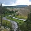
 Hellroaring Creek
6.8 mi 10.9 km • 905' Up 275.8 m Up • 905' Down 275.89 m Down
Tower J…, WY
 Black Canyon of the Yellowstone
12.9 mi 20.7 km • 1,545' Up 471 m Up • 2,036' Down 620.5 m Down
Mammoth…, WY
Lava Creek Trail
4.7 mi 7.6 km • 218' Up 66.47 m Up • 844' Down 257.23 m Down
Howard Eaton Trail: Golden Gate
4.3 mi 7.0 km • 206' Up 62.9 m Up • 1,207' Down 367.81 m Down
Shoshone Lake & Geyser Basin
21.2 mi 34.1 km • 1,204' Up 367.11 m Up • 1,537' Down 468.54 m Down
Old Fai…, WY


0 Comments