Dogs Unknown

Features
Birding · Historical Significance · Views · Wildlife
Description
This trail begins at a parking area off of Tilcon Road by a set of railroad tracks. The trail crosses the tracks and continues into the tidal marsh. The trail is dirt until it becomes a concrete boardwalk that crosses the water.
At the center of this section of the trail, there are a few convenient benches. After returning to the dirt path, the trail climbs slightly before crossing under Pleasent Point Road. It descends from this rocky area and goes back into the marsh.
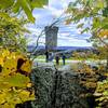
At this point, it crosses a wonderful little footbridge that was constructed inside the skeleton of an older, larger bridge. The trail then continues towards another parking area at the eastern terminus of the trail.
Flora & Fauna
There are multiple osprey nesting platforms all around the trail in the surrounding tidal wetlands.
Contacts
Shared By:
Daniel McCloskey

 Continue with onX Maps
 Continue with Facebook


 Particularly Special Place


 Easy
Easy


0 Comments