
 Continue with onX Maps
 Continue with Facebook


 Particularly Special Place


 Intermediate/Difficult

 Intermediate/Difficult
Land Manager: USFS - Inyo National Forest Office
 Rancheria Falls
1.7 mi 2.7 km • 240' Up 73.27 m Up • 241' Down 73.33 m Down
 Auberry, CA
 Mammoth Crest - Duck Pass Loop
13.2 mi 21.2 km • 2,875' Up 876.21 m Up • 2,890' Down 880.93 m Down
Mammoth…, CA
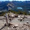
 Mammoth Mountain via Dragon's Back
6.6 mi 10.6 km • 2,419' Up 737.42 m Up • 2,419' Down 737.39 m Down
Mammoth…, CA
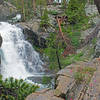
Upper and Lower Rainbow Falls
3.5 mi 5.7 km • 408' Up 124.4 m Up • 408' Down 124.37 m Down
Mammoth…, CA
Tehipite Valley
31.3 mi 50.3 km • 6,375' Up 1943.02 m Up • 6,376' Down 1943.36 m Down
The River Trail
6.5 mi 10.4 km • 1,560' Up 475.59 m Up • 318' Down 96.82 m Down
Mammoth…, CA


0 Comments