Dogs Unknown

Runner Notes
The official finish to
Vitosha 100 involves turning right down the cobbled street and finishing about 3 km from this point.
Description
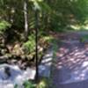
After the bridge in Dragalevtsi, head diagonally up the hill towards the lake. From there, follow the path through the forest until you reach a gravel path. This path will continue for about 500 meters before it turns back to dirt. You'll cross a small river as you climb a hill then transition to a downhill behind a series of houses. From here to Boyana, the trail alternates between up and down; however, it is well covered in the forest and provides the occasional view of Sofia below.
Shared By:
Jonathan Salibra

 Continue with onX Maps
 Continue with Facebook


 Particularly Special Place


 Intermediate


0 Comments