
 Continue with onX Maps
 Continue with Facebook


 Particularly Special Place


 Difficult
Difficult
Difficult
 Difficult
Land Manager: BLM Utah - Moab Field Office
 Professor Creek & Mary Jane Canyon
8.2 mi 13.3 km • 1,105' Up 336.72 m Up • 1,105' Down 336.77 m Down
 Moab, UT
 Fisher Towers Hiking Trail
4.5 mi 7.2 km • 1,813' Up 552.56 m Up • 1,812' Down 552.36 m Down
 Moab, UT
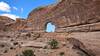
Corona Arch Trail
Moab, UT
Corona Arch Trail
2.2 mi 3.6 km • 367' Up 112 m Up • 367' Down 111.92 m Down
Moab, UT
Jeep Arch / Gold Bar Arch Trail
3.8 mi 6.1 km • 918' Up 279.82 m Up • 923' Down 281.31 m Down
Moab Retreat: Day 1 Full Pint
13.8 mi 22.3 km • 1,830' Up 557.88 m Up • 1,833' Down 558.64 m Down
Moab, UT
Moab Retreat: Day 1 Half Pint
6.7 mi 10.8 km • 1,039' Up 316.75 m Up • 1,044' Down 318.06 m Down
Moab, UT


0 Comments