
 Continue with onX Maps
 Continue with Facebook


 Particularly Special Place


 Very Difficult
Very Difficult
Very Difficult
 Very Difficult
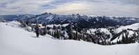
 Mount St. Helens Summer Climbing Route: Monitor Ridge
8.8 mi 14.1 km • 4,489' Up 1368.15 m Up • 4,488' Down 1368.04 m Down

 Amboy, WA
 Lava Canyon Loop
1.2 mi 1.9 km • 257' Up 78.27 m Up • 257' Down 78.34 m Down
Amboy, WA
 Coldwater Peak
12.4 mi 19.9 km • 2,658' Up 810.28 m Up • 2,681' Down 817.02 m Down
Morton, WA
Trapper Creek Out-and-Back
7.6 mi 12.3 km • 1,704' Up 519.52 m Up • 1,704' Down 519.49 m Down
Stevenson, WA
Falls Creek Falls Loop
5.9 mi 9.6 km • 1,425' Up 434.28 m Up • 1,424' Down 434.01 m Down
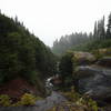
 Panther Creek Falls Trail #137
0.6 mi 1.0 km • 87' Up 26.41 m Up • 86' Down 26.32 m Down
Carson, WA


0 Comments