
 Continue with onX Maps
 Continue with Facebook


 Particularly Special Place


 Intermediate/Difficult
Intermediate/Difficult
Intermediate/Difficult
 Intermediate/Difficult
Land Manager: National Park Service - Bryce Canyon National Park
 Queens Garden Navajo Loop Trail
3.0 mi 4.8 km • 615' Up 187.42 m Up • 615' Down 187.42 m Down

 Panguitch, UT
Navajo Loop
Panguitch, UT
Navajo Loop
1.4 mi 2.2 km • 495' Up 150.77 m Up • 496' Down 151.13 m Down
Panguitch, UT
 Under-the-Rim Trail
22.7 mi 36.5 km • 4,284' Up 1305.81 m Up • 3,549' Down 1081.73 m Down
Panguitch, UT
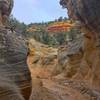
 Willis Creek Out and Back
3.4 mi 5.5 km • 202' Up 61.65 m Up • 202' Down 61.68 m Down
Panguitch, UT
Bull Valley Gorge
4.4 mi 7.1 km • 334' Up 101.88 m Up • 334' Down 101.87 m Down
Panguitch, UT
Red Canyon Loop
2.2 mi 3.6 km • 360' Up 109.88 m Up • 374' Down 113.97 m Down


 Minor Issues


0 Comments