
 Continue with onX Maps
 Continue with Facebook


 Particularly Special Place


 Easy/Intermediate
Easy/Intermediate
Easy/Intermediate
 Easy/Intermediate
 Bambi's Sawtooth Lollipop Loop
3.2 mi 5.1 km • 427' Up 130.3 m Up • 427' Down 130.28 m Down

 Gunnison, CO
 Storm Pass Out and Back
17.1 mi 27.5 km • 4,102' Up 1250.42 m Up • 4,102' Down 1250.41 m Down
Crested…, CO
Rimrock to Uplands Loop
2.2 mi 3.5 km • 404' Up 123.12 m Up • 406' Down 123.82 m Down
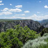
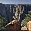
North Vista Trail
6.7 mi 10.8 km • 1,169' Up 356.18 m Up • 1,169' Down 356.24 m Down
Olathe, CO
Courthouse Mountain
3.1 mi 5.0 km • 1,813' Up 552.53 m Up • 1,810' Down 551.75 m Down
Ridgway, CO
Camp 4 Coffee Cart to Cart
19.8 mi 31.9 km • 3,126' Up 952.8 m Up • 3,130' Down 953.97 m Down
Crested…, CO


0 Comments