The western-most section of the Oregon Desert Trail crosses the Oregon Badlands Wilderness, Horse Ridge, and
Pine Mountain. The only reliable water sources are the canal at the sections start, and at Sand Spring at the sections end. Soil composition is diverse herevery sandy on the northwest side of
Pine Mountain, transitioning to white pumice on the flats to the southeast.
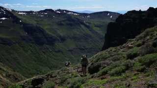
On clear days there are extensive views of the Cascades and Newberry volcanic formations. The lower elevation portions of this section could be used year-round;
Pine Mountain may also be a year-round option depending on snowpack. The sandy soils make for more taxing cross-country terrain, and the climb up to
Pine Mountain involves a nearly 2000-foot elevation gain.
This is an abbreviated description and only includes references a few key waypoints (also shown on the map). Section mileages shown here may differ slightly from the ODT guidebook. A full description of the route can be found in the
Oregon Desert Trail Guidebook
For more info and to download ALL of the waypoints for the ODT, visit
ONDA.org
The only reliable water sources are the canal at the sections start at
Tumulus Trail, and at Sand Spring at the sections end, 36.6 miles from the start. This section combines a series of cross country, trail and 2-track roads.
The trail starts at
Tumulus Trail (CV001, water in canal late-April to Oct.), then follows the
Tumulus Trail for a half mile, then turns south onto the Black Lava Trail. During an ONDA trail work trip in June 2017, volunteers built a new section of trail that starts right before CV004. The route is marked with a series of cairns before joining the Flatiron Rock Trail at CV005.
From the Flatiron Rock Trailhead (CV009) cross Highway 20 to a fence. After climbing over, continue cross-country for 0.8 miles to the west through a juniper forest. Keep a west-bearing to where the ODT crosses a dirt road (CV010) and arrives at a pullout and gate. Pass through the gate and follow a road until it merges with another two-track road. The ODT turns right on this two-track road and climbs for about a mile around the northwest edge of Horse Ridge. At a fork, the ODT follows an overgrown two-track road to the southeast to a two-track junction at a barbed wire gate. Pass through the gate, and climb through one of the wide canyons of Horse Ridge, eventually leveling out.
Here (CV015) turn south and start a 2-mile cross-country section, veering east and south to the prominent ridge. The ODT continues south, descending to a two-track road at the saddle east of Golden Basin (CV018). Here the ODT follows the two-track road to the southeast, descending through a small canyon.
The two-track road comes to a four-way junction and continues south on a dirt road, which turns immediately into OHV Trail 30. The ODT continues following OHV Trail 30 to the east to a junction. Here the ODT turns right (south) on OHV Trail 32, crossing Fort Rock Road and continuing south, where it continues following OHV Trail 32 east along a barbed wire fence. Here the ODT follows OHV Trail 36 south for about a mile into a rocky lava flow, then turns southeast onto OHV trail 30, and arrives at the paved Spencer Wells Road (CV026).
After crossing this road, the ODT takes a shortcut and continues southeast cross-country 0.3 miles up a hill, crosses a barbed wire fence, and arrives at CV027. The ODT takes the eastbound two-track road to a junction of dirt roads and turns right (southeast) on the closed road heading toward
Pine Mountain. The ODT crosses through a fence marking the BLM/USFS boundary and begins the nearly 2000-foot ascent of
Pine Mountain.
Eventually, the old two-track reaches a junction with an active two-track (FS 2017-430) and turns east and continues climbing gradually, merging onto FS 2017-400 and continuing to climb to the south and east. Upon reaching the main
Pine Mountain gravel road (FS 2017), the ODT continues climbing to the south and in about a mile reaches the
Pine Mountain Campground (CV035, about a dozen campsites, free, no water). The ODT descends from
Pine Mountain on Forest Road 2017 to the east of the campground.
The ODT follows road 2017 nearly to the basin floor but turns east on a washed-out two-track road that leads to unreliable Antelope Spring (CV039). At the spring, the ODT continues south on a two-track road, which, after about a quarter mile, veers to the southeast.
The ODT follows the two-track road 2300-300 toward the pine forest, staying on a southeast trajectory. There is a prominent fork, and the ODT stays right (south) on 2300-300. About a quarter-mile later the ODT turns right onto Forest Road 2300-323 and follows this until it reaches a junction.
Here the ODT continues southeast on a two-track road until it reaches a barbed wire fence near the Sand Spring Compensation Station. Crossing the fence, the trail stays on road 2300-310 as it crosses beneath the massive transmission lines, and meets up with red-pumice Forest Road 23. Following this major road south for about a half-mile, the ODT arrives at a four-way junction (CV052), where reliable Sand Spring is located behind wooden fences. Treat all water. The undeveloped Sand Spring is set back in the trees just west of the spring.

 Continue with onX Maps
 Sign in with Facebook


 Particularly Special Place


 Intermediate

 Run the Rock 50 Mile

 Run the Rock Half Marathon
 Broken/Vista Trail Marathon
 La Pine, OR


0 Comments