
 Continue with onX Maps
 Continue with Facebook


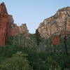
 Particularly Special Place


 Intermediate

 Intermediate
Land Manager: USFS - Coconino National Forest Office
 Soldier Pass Trail
3.6 mi 5.8 km • 433' Up 131.84 m Up • 432' Down 131.8 m Down
 Sedona, AZ
 Sterling Pass Trail
3.1 mi 4.9 km • 1,701' Up 518.57 m Up • 1,701' Down 518.42 m Down
Sedona, AZ
Devil's Bridge Trail
4.0 mi 6.5 km • 528' Up 160.93 m Up • 523' Down 159.27 m Down
West Se…, AZ
Long Canyon Out and Back
7.5 mi 12.0 km • 785' Up 239.17 m Up • 784' Down 238.96 m Down
 Chuckwagon—Brins Mesa
5.7 mi 9.2 km • 723' Up 220.35 m Up • 695' Down 211.97 m Down
West Se…, AZ
Little Horse Trail Out and Back
3.9 mi 6.2 km • 395' Up 120.44 m Up • 395' Down 120.42 m Down
Village…, AZ


0 Comments