
 Continue with onX Maps
 Continue with Facebook


 Particularly Special Place


 Intermediate

 Intermediate
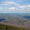
 Winslow State Park Loop
2.6 mi 4.2 km • 1,090' Up 332.17 m Up • 1,089' Down 331.94 m Down
 Andover, NH
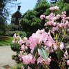
Mt. Cardigan Super Loop
Andover, NH
Mt. Cardigan Super Loop
9.7 mi 15.6 km • 3,074' Up 936.89 m Up • 3,075' Down 937.16 m Down
Grafton, NH
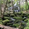
Moose Mountain Trail
4.3 mi 6.9 km • 1,004' Up 306.13 m Up • 1,000' Down 304.88 m Down
Mt. Tom Loop
5.1 mi 8.2 km • 907' Up 276.44 m Up • 907' Down 276.38 m Down
 Walter - Newton Loop
1.5 mi 2.5 km • 158' Up 48.3 m Up • 156' Down 47.69 m Down
 Monadnock - Sunapee Greenway
48.3 mi 77.7 km • 7,936' Up 2418.9 m Up • 8,377' Down 2553.31 m Down


0 Comments