Dogs Leashed

Features
Historical Significance · Lake · Wildflowers

Foothills Park is open to public as of December 2020.
Overview
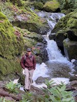
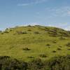
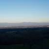
Los Trancos is the longest trail in the Foothills Park. It has scenic views and crosses through several plant communities.
Description
Foothills Parks located in Palo Alto, CA was opened to Public in December 2020.
The park has several trails, the longest of them is
Los Trancos Trail. This is a one-way trail due to COVID restrictions. The route is clearly marked and one-way signs are posted along the route. There is a $5 donation for parking. On weekends and holidays the parking lots get full quite fast. It is recommended to arrive early (by 8am) or prepare to walk extra mile to the trailhead :)
History & Background
In 1958, Russell V. Lee — who founded what's now the Palo Alto Medical Foundation — offered most of the 1,400 acres of land that make up Foothills Park to the city of Palo Alto at a price tag of $1.3 million.
Before the park opened, Palo Alto turned down an offer from Santa Clara County in 1964 to contribute $500,000 toward the acquisition costs — because accepting the county's offer came with a contingency that the park be open to all. Instead, the city limited access to the park to only Palo Alto residents and their guests, starting in 1969, and even made it a misdemeanor for a nonresident to enter the park.
Park opened to non-Palo Alto residents in December 2020 after 50 years
Contacts
Shared By:
Haroon Muhammad

 Continue with onX Maps
 Continue with Facebook


 Particularly Special Place


 Intermediate/Difficult


0 Comments