
 Continue with onX Maps
 Continue with Facebook


 Particularly Special Place


 Intermediate


 Intermediate
Land Manager: City of Boulder Open Space and Mountain Parks
 Shanahan Ridge
3.9 mi 6.3 km • 831' Up 253.22 m Up • 831' Down 253.4 m Down
Marshall Mesa to Spring Brook Loop
11.1 mi 17.9 km • 889' Up 271.11 m Up • 889' Down 271.02 m Down
Superior, CO
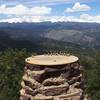
Welcome to Chautauqua
1.3 mi 2.2 km • 436' Up 132.79 m Up • 434' Down 132.4 m Down
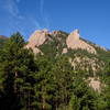
 Second-Third Flatiron Mesa Loop
2.3 mi 3.7 km • 704' Up 214.66 m Up • 700' Down 213.44 m Down
Green Mountain West Ridge
3.9 mi 6.3 km • 633' Up 193.08 m Up • 634' Down 193.23 m Down
Mount Sanitas via Sunshine Lion's Lair Loop
5.3 mi 8.5 km • 1,261' Up 384.48 m Up • 1,282' Down 390.64 m Down
Boulder, CO


0 Comments