 Race - Jun 6, 2020
Dogs No Dogs

Features
Spring · Views · Wildlife
Overview
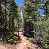
The North Fork course is 100% dirt, mainly singletrack, and some doubletrack and dirt road. Most of the footing is quite good, but there are some steep sections and some rocky sections as you would expect in a trail race. There are several big climbs and downhills, but most of the climb is not extremely steep. Sections along the ridges and along Buffalo Creek are rolling and mostly gentle.
Most of the course is in pine forest, but there are a few burn areas that are open and unshaded. The burn areas offer some beautiful views of the high mountains in the distance.
The altitude ranges from 6,700 to 8,100 feet for the 50K and up to 8,500 feet for the 50 Mile. The elevation gain is about 3,800 feet for the 50K and 6,800 feet for the 50 Mile.
Description
The first 0.9 miles roll mostly downhill on Buffalo Creek Road along Buffalo Creek. Then the course turns left onto
Nice Kitty Trail for a big 3.9-mile rolling climb (with some downhill breaks) through the starkly beautiful Buffalo Creek burn scar. At the top of the climb, runners turn left onto Buffalo Burn Trail for .3 mile to the Colorado Trail and the Colorado Trail Water Station at 5.1 miles.
Turn right onto Colorado Trail, a gently uphill doubletrack. Runners then follow the Colorado Trail for 2 gently rolling miles to Shinglemill Trail, where they turn right and run .2 mile downhill and across FS 550 to theShinglemill aid station at 8.2 miles.
Runners then turn around at the aid station and go back up Shinglemill Trail to Colorado Trail, where they turn right and follow Colorado Trail for 3.6 miles. Tramway is 1.4 miles of downhill, crossing the FS 550 road halfway down and ending at Buffalo Creek Road/543. Turn left on Buffalo Creek, a lovely, gentle doubletrack, and go 1 mile to its end at a big iron gate at Forest Service
Road 550. The course turns right for .1 mile on FS 550 and then left onto Meadows Group Campground Road for .1 mile to the Meadows aid station at mile 14.7 at the Colorado Trail's Buffalo Trailhead.
From Meadows aid runners turn right on Meadows Campground road to do the beautiful 6-mile Green Mountain loop. At the fence .5 mile up the campground road, runners continue straight onto
Green Mountain Trail for 3.5 miles and then turn left (don't go straight/right!) on the Colorado Trail. In 1.3 miles, the course reconnects with the
Green Mountain Trail, and runners turn left on Green Mountain for .2 mile to close the loop at the fence at the top of Meadows Campground Road. Runners turn right onto the road and go .5 mile down to return to Meadows aid station at 20.7 miles.
This next section runners take a .2-mile connector trail from Meadows to get onto the CT. In .4 mile, the CT crosses FS Road 543 (don't turn onto the road) and then starts uphill. There is one more short steep section shortly before the Rolling Creek aid station at 25.6 miles. From Rolling Creek, runners do a 2-mile out and back on the CT. It is a fairly steep uphill on the way out to the turnaround at the high point of the course just over 8,500 feet. Then it's back down to Rolling Creek aid station at 27.6 miles. From there, runners return on the Colorado Trail to Meadows aid station at 32.5 miles to rejoin the 50K course to the finish.
From Meadows head back out the Meadows Campground Road .1 mile to FS 550, where runners turn left on 550 and run on the road (turning right toward Bailey on 550 at the Y in .4 mile where 543 goes straight/left toward Wellington Lake) for .8 mile to where Redskin Creek Trail crosses the road. Runners turn right on Redskin Creek for a .8-mile climb on nice singletrack. Runners continue straight onto Gashouse Gulch Trail for 1.7 miles of mostly downhill, some through the Buffalo Creek burn scar, to the Buffalo Creek aid station at 36 miles.
From Buffalo Creek aid station, the last big climb begins up Baldy Trail. At the wide Gashouse Gulch trail junction, the course turns right on Gashouse and continues .6 mile to the end of the trail at
Miller Gulch doubletrack. Runners turn right on
Miller Gulch and go .2 mile to the Homestead aid station at mile 40.5.
Runners turn left on Homestead for .9 mile to the Skipper/Strawberry Jack junction, turn right on Homestead for another 1.4 miles, and then turn right on
Charlie's Cutoff for 1.4 miles of mostly uphill back to
Homestead Trail. The course then turns left on Homestead for .2 mile back to the Homestead aid station at 44.4 miles.
The 5.6-mile run from Homestead to the finish is almost (but not entirely!) all downhill. Runners go down
Miller Gulch for 2 miles and then turn right onto
Sandy Wash Trail for 2.9 miles to the end of the trail at Buffalo Creek Road/543. Runners then turn left onto Buffalo Creek for the last .7 mile
History & Background
The race benefits the North Fork Volunteer Fire Department, which protects the area where the race is run and for whom the race is named. They have helped to battle a number of wildfires in the area over the years that have changed the landscape, opening broad vistas of the high country and making way for new growth. You'll run through some of the burn areas, but most of the course is in pristine pine and aspen forest.
Contacts
Shared By:
Andrew Hodges

 Continue with onX Maps
 Continue with Facebook


 Particularly Special Place


 Difficult

 North Fork 50K Course

 Pine, CO
 Elk Falls Out and Back
 Colorado Trail (CT)


1 Comment