Dogs Off-leash

Features
Birding · Commonly Backpacked · Fall Colors · Views · Wildlife
Runner Notes
There's lots of rocks, so watch your step.
Description
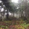
This is, most likely, the last trail you'll take after running the Long Trail (LT) northbound. From the parking area, the trail goes up moderately while following an old forest road. At one point, there is a stream crossing with a rope spanning the width. A little bit further is Journey's End Camp (cabin), which will be on the right, with a sign for water on the left. The trail becomes narrower, steeper, and winding to the boundary marker. The marker is on the boundary with the U.S. and Canada; this is the northern terminus of the Long Trail.
Flora & Fauna
Juncos, bluejays, chipmunks, beech, birch, hemlock, and spruce can be found in this area.
Contacts
Shared By:
David Smith
with improvements
by Matt Kelleher

 Continue with onX Maps
 Continue with Facebook


 Particularly Special Place


 Intermediate/Difficult

 4.2 (5)


0 Comments