
 Continue with onX Maps
 Continue with Facebook


 Particularly Special Place


 Intermediate
Intermediate
Intermediate
 Intermediate
Land Manager: NPS - Topanga State Park
 Green Peak Loop
7.7 mi 12.5 km • 1,649' Up 502.53 m Up • 1,649' Down 502.58 m Down

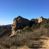
 Eagle Rock Loop
6.6 mi 10.6 km • 1,062' Up 323.7 m Up • 1,073' Down 326.95 m Down
 Saddle Peak
9.0 mi 14.4 km • 2,125' Up 647.58 m Up • 2,125' Down 647.59 m Down
 Lower Franklin Canyon Loop
1.9 mi 3.1 km • 357' Up 108.69 m Up • 375' Down 114.37 m Down
Betty B. Dearing Lollipop
6.7 mi 10.7 km • 1,194' Up 363.95 m Up • 1,195' Down 364.09 m Down
Grand Tour
14.8 mi 23.8 km • 2,781' Up 847.79 m Up • 2,784' Down 848.55 m Down
Agoura, CA


 All Clear


0 Comments