
 Continue with onX Maps
 Continue with Facebook


 Particularly Special Place


 Intermediate
Intermediate
Intermediate
 Intermediate
Land Manager: King County, WA - Parks and Recreation
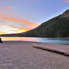
 Rattlesnake Ledge
4.3 mi 6.9 km • 1,111' Up 338.7 m Up • 1,110' Down 338.42 m Down

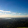
 Riverbend, WA
 Poo Poo Point via Chirico Trail
3.9 mi 6.3 km • 1,619' Up 493.34 m Up • 1,618' Down 493.27 m Down
Issaquah, WA
Poo Poo Point via East Sunset Way Trailhead
7.7 mi 12.4 km • 2,110' Up 643.16 m Up • 2,109' Down 642.96 m Down
Cougar Mountain Series: Race #2 - 8.2 Loop
8.1 mi 13.0 km • 983' Up 299.61 m Up • 992' Down 302.33 m Down
Newcastle, WA
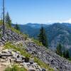
Bandera Mountain
8.2 mi 13.1 km • 3,055' Up 931.15 m Up • 3,054' Down 931.01 m Down
Riverbend, WA
 Thompson Lake via Mt. Defiance
16.1 mi 25.8 km • 5,068' Up 1544.59 m Up • 5,067' Down 1544.42 m Down
Riverbend, WA


0 Comments