
 Continue with onX Maps
 Continue with Facebook


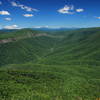
 Particularly Special Place


 Difficult
Difficult
Difficult
 Difficult
Land Manager: North Carolina State Park - South Mountains State Park
 Baker's Mountain Park Loop
4.7 mi 7.5 km • 918' Up 279.94 m Up • 932' Down 284.06 m Down

 Fonta Flora Trail Loop
6.9 mi 11.0 km • 427' Up 130.07 m Up • 426' Down 129.87 m Down
 Glen Al…, NC
 Table Rock Ultras 30k
21.4 mi 34.4 km • 2,533' Up 771.95 m Up • 2,532' Down 771.9 m Down
Glen Al…, NC
Table Rock Ultras 50k
30.5 mi 49.1 km • 4,929' Up 1502.23 m Up • 4,930' Down 1502.79 m Down
Glen Al…, NC
Sinkhole Challenge
7.4 mi 11.8 km • 1,648' Up 502.35 m Up • 1,637' Down 498.92 m Down
Springmaid Splash 10K
6.3 mi 10.2 km • 607' Up 185.12 m Up • 609' Down 185.61 m Down


 All Clear


0 Comments