The 8-mile, soft surface trail network at Philip Miller Park consists of singletrack trails divided into four different, but interconnected loops. There is also 2.5-miles of paved trails within the park that are not included in this run. The trails explore all the valleys, knolls, and high points of the 270-acre park, including up close looks at all the zip line structures.
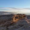
A unique feature on this run is the Challenge Hill, with 200 steps that climb 178 feet in elevation.
This is an active regional park that includes a zip-line course and adventure playground area as well as mountain bikers. Trail users should be aware of all park users and use caution on the trail and in the parking lots.
The North-facing sections can be muddy in the winter and spring.
There is no shade on the course, so it is best run early in the morning to avoid sun exposure and heat. Be sure to carry your own water as the only water source is at the MAC.
Parking is available in the park and the main parking lot at the Miller Athletic Complex. There are additional trail access points on Plum Creek Parkway and Wolfensberger Road (future). In the near future, the trails will also connect to Ridgeline Open Space and the
Stewart Trail network to the west; the Ridgeline Trailhead parking lot is located on Coachline Road.
Starting from the parking lot at the Miller Athletic Complex, this run can be done in either direction. However, to start it off with a bang, head over to Challenge Hill and run up the 200 steps to the top.
Once at the top, take in the view of the surrounding area before following the Blue Trail to the right as it switchbacks down the mountain through sage bush and grasslands.
At the first intersection, hang a left and head over to the
Red Loop. Once you hit the
Red Loop, turn left and enter the awesomeness that is the Philip Miller Park trail network.
This network basically is one big loop, connected together by four different colored loops: the Red, Green, Gold and Purple Loops. Be sure to follow the sign. At almost every trail junction, you'll be turning left, except for on the
Purple Loop.
This 1.4-mile stretch on the
Red Loop weaves in and out and up and down around the southern part of the park, allowing great views of the mountains to the south.
Your next trail junction will be with the
Green Loop. Continue left/straight onto the
Green Loop and begin your climb up to the southwestern side of the park. Once you reach the top of this section, you'll get outstanding views of the foothills to the west.
After 1.2 miles, you'll come to the start of the
Gold Loop. Again, turn left and follow this trail along the top of the mountain. After about a half a mile, you'll start to get a lot of twists and turns and ups and downs, so be ready.
In the future, you'll pass a trail that will connect over to the Ridgeline Loop, allowing for a much longer trail romp. The town of Castle Rock is building a pedestrian bridge over Wolfensuburger Road, which should be done by the summer of 2016.
To stay on this run, continue on the
Gold Loop to your trail intersection with the
Purple Loop. This intersection is a "four-way stop" so stay to the left to continue on this route.
Now you are on the
Purple Loop, which is at the northernmost section of the park. After about one half mile, be sure to look up and take in the view of the Castle Rock and the surrounding buttes.
After 0.6 miles of running on the
Purple Loop, you'll come to one of two spots where you need to actually turn right. Be sure to follow the purple trail sign and head back to the "four way stop" intersection with the
Gold Loop. Turn left, and follow the
Gold Loop 0.6 miles back to the
Red Loop. You pass a few short trails that drop down to the road below. Just ignore these and stay on the
Gold Loop.
Once back on the
Red Loop, you'll go about a quarter of a mile back to the intersection where you started the big loop of the park. Turn left here and then turn right to go back to the
Blue Loop and Challenge Hill. To keep from going down the stairs that you started with, turn left and run the Blue Loop across the bottom of the hill and back to your car.
This run passes mostly through native grasslands and scrub oak, providing wonderful wildflower sightings. Be aware of rattlesnakes in the summer.

 Continue with onX Maps
 Continue with Facebook


 Particularly Special Place


 Intermediate/Difficult

 4.5 (11)


0 Comments