
 Continue with onX Maps
 Continue with Facebook


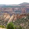
 Particularly Special Place


 Intermediate/Difficult
Intermediate/Difficult
Intermediate/Difficult
 Intermediate/Difficult
Land Manager: BLM Colorado - Grand Junction Field Office
 Gorge(ous) 10-miler Loop
10.2 mi 16.4 km • 1,759' Up 536.26 m Up • 1,758' Down 535.96 m Down

 Grand Mesa Ultras 100 Mile Trail Race
100.1 mi 161.1 km • 10,530' Up 3209.69 m Up • 10,538' Down 3212.13 m Down
Cedaredge, CO
Grand Mesa Crag Crest Loop
10.9 mi 17.6 km • 1,521' Up 463.69 m Up • 1,540' Down 469.29 m Down
 Cedaredge, CO
Rough Canyon Loop
Cedaredge, CO
Rough Canyon Loop
4.5 mi 7.3 km • 1,070' Up 326.22 m Up • 1,067' Down 325.2 m Down
Redlands, CO
 Devils Kitchen
1.1 mi 1.8 km • 242' Up 73.74 m Up • 242' Down 73.82 m Down
Redlands, CO
 Coke Ovens Out and Back
1.0 mi 1.7 km • 156' Up 47.59 m Up • 156' Down 47.59 m Down


0 Comments