
 Continue with onX Maps
 Continue with Facebook


 Particularly Special Place


 Intermediate
Intermediate
Intermediate
 Intermediate
Land Manager: Bureau of Reclamation - Central California Area Office
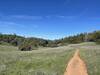
 Training Hill to Pig Farm to Robie Trail Loop
2.6 mi 4.2 km • 752' Up 229.08 m Up • 751' Down 228.92 m Down

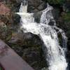
 Black Hole of Calcutta Falls
2.1 mi 3.4 km • 121' Up 36.91 m Up • 122' Down 37.04 m Down
Olmstead Loop Trail
9.0 mi 14.6 km • 978' Up 297.99 m Up • 986' Down 300.68 m Down
 Foresthill Divide Loop
11.2 mi 18.0 km • 1,087' Up 331.19 m Up • 1,087' Down 331.23 m Down
Auburn…, CA
Hidden Falls Loop
8.6 mi 13.8 km • 811' Up 247.31 m Up • 812' Down 247.45 m Down
North A…, CA
Marshall Monument Loop
3.5 mi 5.6 km • 600' Up 182.96 m Up • 585' Down 178.21 m Down
Placerv…, CA


0 Comments