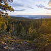
The view from The Grand View is excellent, especially at sunset when the sun sets on the valley far below. There is a (no services) campground at The Grand View with two or three basic tent sites, some benches, firepits, and a pit toilet.
The trail north of the viewpoint and campsite is far less traveled and can be overgrown at times, especially after a wet spring. Follow the pink and black signs or flagging tape and bring a good map. Except for the southern section of this part of the High Rim Trail, there is little elevation gain or loss as the trail tends to follow the high points rather than ascend or descend steeply.
Virtual Tour of Okanagan High Rim Trail: Segment 5 - James Lake FSR to Goudie FSR
We use cookies to improve your browsing experience, to show you
personalized content, and for statistical purposes. By continuing
to navigate our website, you accept our use of cookies. Read our
Privacy Policy to learn more.

 Continue with onX Maps
 Continue with Facebook


 Particularly Special Place


 Intermediate


0 Comments