
 Continue with onX Maps
 Continue with Facebook


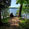
 Particularly Special Place


 Easy/Intermediate
Easy/Intermediate
Easy/Intermediate
 Easy/Intermediate
Land Manager: Cataraqui Region Conservation Authority
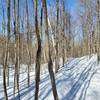
 K&P Trail
62.8 mi 101.0 km • 1,320' Up 402.29 m Up • 890' Down 271.27 m Down

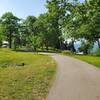
 Lake Ontario Park
2.3 mi 3.8 km • 65' Up 19.88 m Up • 65' Down 19.89 m Down
Lemoine Point Loop
2.4 mi 3.9 km • 100' Up 30.44 m Up • 96' Down 29.34 m Down
Kingston, ON
 Mine Loop to Point Spur
2.7 mi 4.3 km • 272' Up 82.76 m Up • 267' Down 81.46 m Down
Kingston, ON
Landon Bay Loop
2.3 mi 3.7 km • 173' Up 52.65 m Up • 189' Down 57.6 m Down
Gananoque, ON
 Rock Dunder Loop
2.9 mi 4.7 km • 316' Up 96.44 m Up • 308' Down 94.01 m Down
Gananoque, ON


0 Comments