
 Continue with onX Maps
 Continue with Facebook


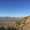
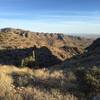
 Particularly Special Place


 Intermediate
Intermediate
Intermediate
 Intermediate
 XTERRA Estrella Mountain 20K Trail Run
12.8 mi 20.6 km • 865' Up 263.55 m Up • 857' Down 261.11 m Down
 Avondale, AZ
 Bursera Loop
5.9 mi 9.5 km • 1,007' Up 307.04 m Up • 1,007' Down 307.08 m Down
Mesquite Canyon Loop
8.7 mi 13.9 km • 1,543' Up 470.39 m Up • 1,542' Down 469.99 m Down
 Citrus…, AZ
XTERRA White Tanks Trail Run 8k
Citrus…, AZ
XTERRA White Tanks Trail Run 8k
4.5 mi 7.2 km • 210' Up 63.95 m Up • 204' Down 62.25 m Down
Citrus…, AZ
 XTERRA White Tanks 20k
12.6 mi 20.4 km • 1,743' Up 531.14 m Up • 1,742' Down 531.04 m Down
Citrus…, AZ
North Top Summit
0.8 mi 1.4 km • 525' Up 160.05 m Up • 0' Down 0 m Down


0 Comments