This is a beautiful route in Coyote Lake - Harvey Bear Ranch County Park that samples the woods, meadows, grass hills, Coyote Lake and high ridge views from Coyote Ridge. The golden grasses of summer and autumn turn bright green in the winter and spring. Spring also brings an abundance of wild flowers, MANY types of wildflowers. Wildlife, especially deer and soaring birds emerge in the quieter hours such as early morning and late afternoon.
The Coyote Lake and Ridge Run begins and ends at the parking area of the Mendoza Ranch Entrance to Coyote Lake - Harvey Bear Ranch County Park on Roop Road.
Coyote Ridge Trail (start - mile 2.5)
From the parking area take the
Access Trail to its trail junction with
Coyote Ridge Trail and
Mendoza Trail. Go right here onto
Coyote Ridge Trail.
For the first 1.1 miles on
Coyote Ridge Trail, this route runs through grass meadows on the east side of Coyote Ridge. Trees, mostly oaks, border these meadows. Mummy Mountain, part of Coyote Ridge, rises to the left of the trail. Coyote Lake is to the right, below the trail, but hidden. However, Palassou Ridge on the far side of Coyote Lake can be seen.
At the 1.1 mile mark of
Coyote Ridge Trail, a saddle in Coyote Ridge at the north end of Mummy Mountain is reached. A series of trail junctions are here—
Mendoza Trail,
Campground Trail, and finally
Gaviota Trail. Views to the west open up, as Santa Clara Valley below and the Santa Cruz Mountains can be seen from this saddle.
After passing
Gaviota Trail, this run continues on
Coyote Ridge Trail going through grass meadows with stands of oaks. Coyote Lake can now be seen below, to the right. The trail is still on the east side of the ridge but very close to the ridge top now, providing occasional views of Santa Clara Valley and the Santa Cruz Mountains to the west.
Valley Oak Trail (mile 2.5 - 3.7)
Calaveras Trail is reached at the 2.4 mile mark of
Coyote Ridge Trail, Go right here onto
Calaveras Trail.
Calaveras Trail crosses a grassy meadow where the
Valley Oak Trail junction is found. Coyote Lake can be seen below. Go right onto
Valley Oak Trail.
Valley Oak Trail parallels the road but is far enough from the road to not see or hear it. It is a very pretty trail through the woods and meadows with wildflowers in the spring. Basically flat, it is very easy to navigate. Starting off in a meadow,
Valley Oak Trail enters the sunlit woods and passes
Ohlone Trail after .1 miles.
After about another .2 miles on
Valley Oak Trail, the woods thin and an open meadow with views of Coyote Lake is reached. The trail crosses the meadow to re-enter woods, only to come out of them again at another meadow at the
Campground Trail junction where
Valley Oak Trail ends.
Campground Trail to Mummy Mountain Trail (mile 3.7 - 4.1)
Turn right onto
Campground Trail and climb through a meadow for .15 miles to reach
Coyote Ridge Trail and the saddle in Coyote Ridge at the north end of Mummy Mountain. At this trail junction, turn left onto
Coyote Ridge Trail, followed almost immediately by a right onto
Mendoza Trail, and then a left onto
Mummy Mountain Trail.
Mummy Mountain Trail (mile 4.1 - end)
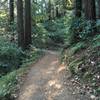
Mummy Mountain Trail enters the woods and begins climbing the steep north end of Mummy Mountain on a few switchbacks. Coyote Lake can be seen below, through breaks in the trees. The trail emerges from the woods on the eastern side of Coyote Ridge as the climb eases... temporarily. After another short uphill section through more woods, the woods thin and the climb ends as the top of Mummy Mountain is reached.
The top of Mummy Mountain is all broad flat meadows with spring wildflowers. There are views beyond the edges of this "table-top", but the immediate beauty is in these high meadows. Take your time to enjoy ambling through them for over 0.5 miles. There is a picnic table and viewpoint bench along the way.
After enjoying the meadows and views,
Mummy Mountain Trail winds through woods and open sections as it descends the southern end of Mummy Mountain on the eastern side of Coyote Ridge. Emerging for good from the woods into the grassy hills,
Mummy Mountain Trail ends at a trail junction with
Mendoza Trail.
From
Mummy Mountain Trail, go left onto
Mendoza Trail for 0.35 miles to the
Coyote Ridge Trail and
Access Trail junction. Continue straight here, onto the
Access Trail to return to the parking area.
You'll find oak-studded grass hills, woods dominated by oaks, and a large variety and abundance of spring wildflowers. Deer, wild turkeys, and many bird types can be found here.

 Continue with onX Maps
 Continue with Facebook


 Particularly Special Place


 Intermediate

 Henry Coe (Jackson Field, Wasno Ridge, Bowl Trail)

 San Martin, CA
 Middle Ridge Loop
 Waterfall Loop Nature Trail


0 Comments