Dogs Off-leash

Features
Commonly Backpacked · River/Creek

This loop is within the Grand Staircase-Escalante National Monument, and federal monument regulations and restrictions apply here. Practice Leave No Trace (LNT) backcountry skills and ethics. Camp 100 feet from fragile areas. Pack out all waste and use portable human waste bags. Park only in disturbed areas to protect soil crust and vegetation. Overnight permits are required for all overnight backpacking trips.
Flash floods are possible at any time of the year.
Overview
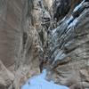
An adventurous and enjoyable loop that leads runners through some of the stunning canyons, washes, and next to the rivers for which this area is famous.
Need to Know
Access to the
Sheep Creek Trail is via the Skutumpa Road, which is a dirt road that can become slick and impassable if it gets wet. Be sure to stop at the BLM Visitor Center in Cannonville to pick up an overnight permit and get the latest weather and road condition information.
Flash floods are possible at any time of the year, so watch the weather and always camp on high ground. Be prepared to wade as you work your way up or down the Paria River. There is usually water in the Paria River but it's also usually silty and will require filtration and treatment before consumption. Water may also be available in Sheep Creek but not with any regularity.
Description
This is a beautiful area with astounding, colorful cliffs and interesting side canyons to explore. It is also a lot less crowded than areas in and around the Paria River. This adventure starts at the Sheep Creek trailhead on Sheep Creek, about 6 miles south of Cannonville, Utah. There are no amenities at this trailhead other than a dirt parking lot alongside the road.
Drop to the creek bed and simply follow it down Sheep Creek. There is no trail, so just pick the easiest route for yourself. At 1.6 miles from the trailhead you'll pass the mouth of Willis Creek and at 5.9 miles, the mouth of
Bull Valley Gorge. At 6.5 miles you'll pass the mouth of another unnamed side canyon and then, at 7.5 miles from the trailhead, Sheep Creek's confluence with the Paria River. From here you have the option of exploring further downstream along the Paria River.
But for this adventure, turn north here and head upstream along the Paria River. You'll very likely have to ford the river repeatedly, so come prepared with footgear that can take being repeatedly soaked. Be careful crossing the river, as sometimes the water is deeper than it looks.
Flash floods are possible any time of year, so watch the weather and get to high ground if it looks threatening.
There are no significant side canyons along the river until you hit Rock Springs Creek at 3.2 miles above the confluence. This canyon can be used to leave the Paria River on use trails and old roads leading northeast to Cottonwood Canyon Road near Kodachrome Basin State Park.
At about 5 miles above the confluence, you have the option of continuing north along the river through the Little Dry Valley or turning west and climbing onto the plateau west of the river. To make the loop without a shuttle, climb away from the Paria River into an unnamed drainage due south of Point 5966. Here you'll find the end of an old ranch road that runs across the plateau. From the river to the end of this old road is the only truly cross-country section of this journey. The terrain is open and easy to traverse; just stay high on the slopes of Point 5966 to avoid pour-offs lower in the unnamed drainage.
Once on the old ranch road, simply follow it across the plateau—with a view west toward Bryce Canyon National Park—and directly back to the
Sheep Creek Trail. You'll pass two side roads (one going north, the other south) but stay on the most obvious one that goes west and then northwest.
Contacts
Shared By:
BK Hope

 Continue with onX Maps
 Continue with Facebook


 Particularly Special Place


 Intermediate

 Bull Valley Gorge

 Navajo Loop
 Panguitch, UT
 Toadstools Trail


0 Comments