
 Continue with onX Maps
 Continue with Facebook


 Particularly Special Place


 Intermediate
Intermediate
Intermediate
 Intermediate
Land Manager: North Carolina Forest Service - Dupont State Forest
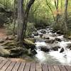
 DuPont Waterfall Bonanza
14.1 mi 22.7 km • 1,472' Up 448.73 m Up • 1,503' Down 458.01 m Down

 Jones Gap Loop
12.6 mi 20.3 km • 3,318' Up 1011.38 m Up • 3,319' Down 1011.63 m Down
 Slater-…, SC
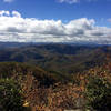
Looking Glass 50 Miler
Slater-…, SC
Looking Glass 50 Miler
49.6 mi 79.8 km • 7,768' Up 2367.78 m Up • 7,710' Down 2349.92 m Down
Brevard, NC
Art Loeb Trail
31.1 mi 50.1 km • 7,578' Up 2309.92 m Up • 6,409' Down 1953.61 m Down
Brevard, NC
Twin Falls Out-and-Back
2.0 mi 3.2 km • 220' Up 67.07 m Up • 220' Down 67.09 m Down
Brevard, NC
Glassy Mountain
3.3 mi 5.3 km • 601' Up 183.25 m Up • 601' Down 183.27 m Down
Flat Rock, NC


0 Comments