Dogs Leashed


Closed at night.
Description
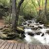
This is the main trail within Bracken Preserve. Beginning at the parking area at the end of Pinnacle Drive, and connecting with Forest Service road 475-C in Pisgah National Forest.
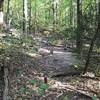
This trail features 1000' of elevation gain from the trailhead to the high ridge which marks the USFS boundary. The beginning of the trail is tight and features several sharp switchbacks due to the narrow conservation easement granted to allow access to the Bracken Preserve property.
Bracken Mountain Trail is marked with blue blazes. All trails are singletrack with no major obstacles, and plenty of tight turns and ascents and descents, making for a solid medium difficulty trail. You'll very rarely get level terrain.
Bikers, hikers, and runners frequent the preserve, though it's not as crowded as the Dupont and Pisgah forest trails. The steep ascent out of the parking lot (.5 miles of continual uphill) turns off a lot of casual runners.
Contacts
Shared By:
Aaron Bland
with improvements
by Mark Hall

 Continue with onX Maps
 Continue with Facebook


 Particularly Special Place


 Difficult

 4.3 (4)


0 Comments