
 Continue with onX Maps
 Continue with Facebook


 Particularly Special Place


 Intermediate/Difficult
Intermediate/Difficult
Intermediate/Difficult
 Intermediate/Difficult
Land Manager: USFS - Uwharrie National Forest Office
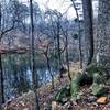
 Fall Mountain Trail
4.2 mi 6.8 km • 545' Up 166.01 m Up • 546' Down 166.47 m Down
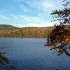
 Badin Lake Trail #94
5.4 mi 8.7 km • 226' Up 68.76 m Up • 226' Down 68.9 m Down
Morrow Mountain
5.8 mi 9.3 km • 892' Up 271.88 m Up • 892' Down 271.93 m Down
Uwharrie Romp
12.1 mi 19.4 km • 1,526' Up 465.16 m Up • 1,537' Down 468.38 m Down
Birkhead Mountain Wilderness Loop
9.8 mi 15.8 km • 995' Up 303.34 m Up • 995' Down 303.35 m Down
 Buffalo Creek Preserve Trail
4.2 mi 6.7 km • 192' Up 58.59 m Up • 192' Down 58.57 m Down


0 Comments