Dogs Leashed

Features
Birding · Fall Colors · River/Creek · Views · Wildlife

Closure dates are posted on signs when entering Camp Mack land. These exclude the
Horseshoe Trail.
Overview
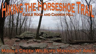
The highlights of this route are the rock formations and Eagle Rock vista. There is also the remnant of an old iron forge, if you want to bushwhack a bit.
Need to Know
Part of the trail travels through State Game land, so wear some orange, especially in fall. There are signs that post dates that the trails are closed to the public due to Boy Scout retreats (not including the
Horseshoe Trail). Pretzel Hut is a restaurant that is wonderful for ice cream or BBQ sandwich at the end of your trip.
Runner Notes
There are lots of rocks, pebbles, and roots on the trail, but it is used by many trail runners.
Description
Parking is available at the Pretzel Hut on Rt 501 and another parking area is located at Rt 322 and Pumping Station Rd. This route travels along a section of the 140-mile historic
Horseshoe Trail (yellow blazed) and through part of Camp Mack (a Boy Scout camp). Equestrians and mountain bikes also use these trails. Some the loop is along dirt access roads. Sometimes you can see small lean-tos made by the Boy Scouts.
Use caution, as rocks and small boulders can be found all over the trails. There are trees growing around some of the rock formations, and these are beautiful. Eagle Rock is a vista where you can see all the way over to the Blue Mountains (where the AT runs). Near the Route 322 exit, there is natural spring that once had a stone wall. Several years ago, the stone wall was vandalized and knocked down, but the springs are still there. There are many other trails crisscrossing this area.
Turn by turn: From the parking area at the Pretzel Hut, work your way through the kids ghost town where you'll pick up the
Horseshoe Trail, which is noted by yellow blazes. This will take you uphill to a dirt access road (Camp Road). Turn right here and follow the trail until it forks.
Turn left and continue downhill. On the right, you'll see some rock formations at the top of the incline. If you bushwhack to the lower end of those formations, you'll come to the old forge. Continue downhill on the trail.
You'll see a sign for
North Valley Trail on the right. When the trail comes to a T, turn right and follow it across a small stream. After crossing the bridge, continue up
Big Timber Trail (more or less straight ahead).
Follow
Big Timber Trail to
Gameland Trail.
Gameland Trail will come to a T; turn right, and soon you'll pick up the blue blaze of Big Rocks Trail. You'll cross a power line clearing. Shortly after, take note of the rock formations. Follow the blue blaze (there are several paths that follow near the blue blaze trail, it is fun to explore around the rocks). You'll go down a steep rocky hill and cross a small stream. The blue blazes end on the
Horseshoe Trail.
You can turn right and go out to the spring and Route 322 then turn around, or you can turn left and follow the yellow blazes up to Eagle Rock (about 1.3 miles). You'll pass or cross several trails and an access road. Keep following the yellow blazes. The trail is well marked. Follow the yellow blazes past Eagle Rock (you'll know it is right place, because Scouts painted "Eagle Rock" on it). The yellow blazes with bring you back to Camp Road. Turn right and then left back onto the
Horseshoe Trail, which will bring you back down to the Pretzel hut.
Camp Mack Trail Map:
sambabiker.com/samba/wp-con…
Pretzel Hut website:
pretzelhut.com/
Flora & Fauna
Lots of toads and salamanders, and many deer can be seen, especially if you are a quiet visitor. I swear I once saw an emu running through the trees. Plants: fern, mountain laurel, jewel weed, moss, lichens, oak, poplar, maple, sassafras, etc.
History & Background
The
Horseshoe Trail (H-ST) is a horseback and foot trail that begins in Valley Forge National Park and continues westward for 140 miles to its terminus at the Appalachian Trail on Stony Mountain near Fort Indiantown Gap. Historically, it is closely related to the early iron industry in PA. For more information, visit
hstrail.dreamhosters.com/ab…Shared By:
Deanne Weaver

 Continue with onX Maps
 Sign in with Facebook


 Particularly Special Place


 Intermediate

 Mt. Gretna Loop

 Cornwall, PA
 Charlie Horse Trail Half Marathon
 Turkey Hill Trail/Low-Grade Hi-Lo Loop


 All Clear


0 Comments