Dogs Off-leash

Features
Lake · River/Creek · Swimming · Views · Wildlife
Overview
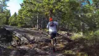
Even though this is a well used 4-wheeler trail, it is sufficiently technical. The first kilometer or so is on a dirt road (a good way to warm-up). Overall, this is a nice run through mixed forest with a great view at the top.
Need to Know
This trail is fairly remote, so bring extra gear. If going during hunting season (usually from early Oct to late Nov), wear your blaze orange. Be sure to check www2.gnb.ca/content/dam/gnb/Departments/nr-rn/pdf/en/Wildlife/HuntTrap.pdf for updated information.
There are no trail markers, so pay attention to the map and your location to stay on the right path (there are some side routes that will take you to the dim weeds). Four wheelers and side-bys use this trail frequently as it is a shared trail. They are always friendly and often amazed to find that you are running.
Runner Notes
This route is chock-full of rocks, roots, and nice step-ups. Be sure to bring your big boy pants for this endevour.
Description
The trailhead, if you can call it that, looks like someone's driveway - find it using the
Trail Run Project mobile app. Keep going past some old buildings as the road starts to get a little rougher. Continue on and you'll come to a tunnel. The first few miles are on a rough gravel road, so expect to see some 4-wheelers and side-byes on the trail. They are generally very friendly and encouraging when they learn of your plans. Be sure to say "Hi" and give them a thumbs up for givin' 'er.
At ~3.75 miles (~6 km) there is a fork in the trail, you can go either way as they re-join quickly. Just after the trails join up again there is a left, over a small bedrock rise that is a bogus trail. Make a right at this section! The trails continues through mixed hardwoods with a gradual climb.
Once you get close to the summit of Turtle Mountain, you are faced with a very steep, but short climb on smooth granite ledges. The view is awesome with Turtle Lake below to the south and The Bay of Fundy in the distance.
Flora & Fauna
Expect to see migrating raptors in the spring and fall. Moose, bear and coyote are also present as well as red fox.
Shared By:
Bryan Gagner

 Continue with onX Maps
 Sign in with Facebook


 Particularly Special Place


 Intermediate/Difficult

 4.5 (6)


1 Comment