Dogs Off-leash

Features
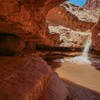
River/Creek · Views
Overview
A great 15-mile loop in the San Rafael Swell. The runner is lead through steep and narrow, winding canyon walls. There is not a significant gain in elevation, but plenty of wading, which can add some difficulty and fun.
Need to Know
Water may be too cold to traverse in winter. Flashflood danger is significant.
Description
The run is an approximately 15-mile loop, much of which is comprised of wading in Muddy Creek between steep and narrow canyon walls.
Begin at the Tomsich Butte Trailhead. Proceed downstream from the Tomisch Butte Trailhead. After two miles, you'll encounter Penitentiary Canyon on your left. After you pass Penitentiary Canyon, the canyon walls begin to narrow. The creek becomes significantly deeper and you may have to wade up to your waist at this point, depending on the time of year.
Approximately five miles after you pass Penitentiary Canyon, you'll encounter Music Canyon on your left. I recommend using the
Music Canyon Route and scrambling up the beautifully sculpted, narrow slot to Music Canyon. Go up as high as you feel comfortable until you are eventually cliffed out by a large dry falls. Return back down the slot to Muddy Creek.
Turn around in Muddy Creek and proceed upstream. After approximately two miles, when the canyon has opened up, there will be a side canyon on your left at GPS coordinate (38.645038, -110.985365). Alternatively, you can continue upstream from here back to the Tomsich Butte Trailhead.
Continue up the side canyon for approximately 2,000 feet and exit this canyon to the north into a smaller canyon. Follow many options of side canyons to the north until you can exit up to the mesa top. Now your goal is to find an old uranium mining road, the
Winding Mining Road Trail, that traverses at the base of the butte.
Follow the
Winding Mining Road Trail north, as it winds its way along several side canyons. This road can be very steep and washed out in certain places, so use caution. Do not fret if you lose the road, just keep working your way north. Eventually, the road will rejoin Muddy Creek at approximately half of a mile south of the Tomsich Butte Trailhead. Work your way upstream to head back to your car.
An alternate route is the
Chute of Muddy Creek trail which will take you further downstream and deeper into the canyon until you reach the Hidden Splendor Airstrip. This alternate route requires a two-car shuttle, leaving one car at the Tomsich Butte Trailhead and the other 16 miles away at the Hidden Splendor Airstrip.
History & Background
The road used to traverse back is an old mining road used during the Utah uranium boom of the late 1940s and early 1950s.
Contacts
Shared By:
Matthew Clarkson

 Continue with onX Maps
 Continue with Facebook


 Particularly Special Place


 Difficult

 4.3 (3)


0 Comments