Dogs Leashed

Features
Views · Wildflowers · Wildlife

Tom Mays Unit is open from 8 am to 5 pm daily. Off-hours access is permitted and is via a small parking area at the gate off of Transmountain. Overnight camping is available.
A ranger station, usually only staffed on weekends in the warmer months, is located a mile inside the entrance. Adult entrance fees are $5 per person, or $2 in groups; children 12 and under are free. When the station is not staffed, use the pay box next to the station.
Runner Notes
Trails around the Franklin Mountains are often rocky and technical, so users unfamiliar with rough terrain should use caution. Trail shoes with rock plates are strongly recommended.
El Paso is in the desert, so plan around the climate. Summers are regularly in the 90's or above; winters will drop to the 30's and 40's. Lightning storms are frequent in the late afternoons during the warmer months. Winds are frequent and gusts over 50 mph are not unusual. Dust storms in the late spring can be hazardous and reduce visibility to less than a quarter mile. Check the weather before you go, and let someone know where you will be.
Description
Spanning flatlands, arroyos, hills and cliffsides, Lower Sunset has something for everyone. The trail can be accessed from parking areas on the south and north ends of the Tom Mays Unit, and a complete loop can be made by connecting with
Upper Sunset,
Tom Mays Trail, or the park road.
Beginning from the south side, Lower Sunset departs a picnic area along a wide, flat doubletrack that once served as a dirt access road. A turnoff to the
Beginner's Loop is found right at the beginning which can be taken to add mileage; it connects back with the main trail a quarter mile later. The path turns to the north, eventually narrowing to singletrack and beginning in earnest.
The trail hairpins down to an arroyo crossing and climbs back out to a fork in the trail, marked by a sign. An intermediate segment branches to the right, while a slightly more challenging shortcut (rated difficult by the sign, but for mountain bikers, not runners) goes to the left. After rejoining, the trail crosses another arroyo at the two-mile mark. A steady, mile and a half long climb follows, weaving up foothills.
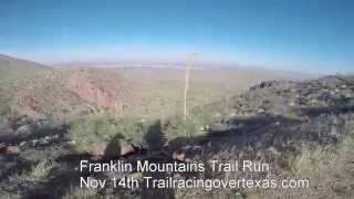
At the top, a shortcut to the north parking area splits right. The path then doubles back west on a narrow cliffside track, with amazing views of the desert valley. This is the Lower Sunset's highlight and one of the nicest trail segments in West Texas. The trail circles the hill clockwise, passing turnoffs for the
Bike Loops, and entering another long, steady climb as it widens again to doubletrack. The incline becomes much steeper passing the second crossing with
Schaeffer Shuffle, making for a demanding, but rewarding finish. The trail tops out in the north parking area.
Flora & Fauna
Desert plants tend to bloom in waves in spring and summer after the short periods of rain that El Paso experiences.
Ocotillo tend to turn green and blossom first, followed by barrel and claret cup cacti, and finally flowers and prickly pears.
Animals are mostly limited to jackrabbits, lizards, and small birds. Roadrunners will dart across the trail at times, and hawks circle overhead, looking for prey. Coyotes are hard to spot and tend to only come out after dusk, though they leave runners alone.
Keep an eye out for snakes. They avoid the hot desert sun and are more common during the winter months. Most are harmless, but rattlers are a part of the local wildlife. Give them a wide berth, and if they're blocking the trail, tossing a few rocks in their direction tends to be enough incentive for them to leave.
Contacts
Shared By:
Brendan Ross

 Continue with onX Maps
 Sign in with Facebook


 Particularly Special Place


 Difficult

 Lower Sunset Alternate Loop

 Franklin Mountains Trail Run 50K
 Canutillo, TX
 Tour de Lost Dog


0 Comments