Dogs Leashed

Features
River/Creek
Need to Know
Parking is available at the Newnan Centre or Summerlin Trailheads. Bike racks and repair station at Newnan Centre. Benches, trash cans, and pet waste stations are abundant.
Description
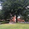
The LINC is a new, exciting, multi-purpose trail built on public rights of way and green space, creating a 26-mile network of paved paths for recreating and socializing in Newnan, Georgia.
Mile Marker 0.0 is located on Highwoods Parkway. This section of the LINC features woods, bridges, a tunnel under Lower Fayetteville Road, a mural, a big hill, and a healthy dose of peace and quiet. Phase 1 is approximately 1.4 miles long, ending on Newnan Crossing Boulevard near the Kroger shopping center.
The LINC trail system is enjoyed by runners, skaters, bicyclists, and people using non-motorized vehicles.
Contacts
Shared By:
Brent Snodgrass

 Continue with onX Maps
 Continue with Facebook


 Particularly Special Place


 Easy
Easy


0 Comments