
 Continue with onX Maps
 Continue with Facebook


 Particularly Special Place


 Intermediate

 Intermediate
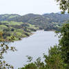
 Briones Reservoir Loop Trail
13.4 mi 21.6 km • 1,081' Up 329.57 m Up • 1,087' Down 331.3 m Down
Temescal Loop
2.0 mi 3.2 km • 109' Up 33.32 m Up • 110' Down 33.42 m Down
Educational Loop
4.3 mi 6.9 km • 622' Up 189.54 m Up • 621' Down 189.4 m Down
 Richmond Marina Bay Trail
8.1 mi 13.0 km • 23' Up 7.07 m Up • 23' Down 7.05 m Down
 El Cerrito, CA
Rim Trail
El Cerrito, CA
Rim Trail
5.2 mi 8.3 km • 903' Up 275.09 m Up • 901' Down 274.55 m Down
Lafayette, CA
Ohlone-Crystyl Ranch Loop
5.5 mi 8.9 km • 734' Up 223.87 m Up • 747' Down 227.67 m Down


0 Comments