 Race - Jul 10, 2021
Dogs Unknown

Overview
Awesome adventure on the Continental Divide.
Description
The race starts at Bannock Pass (11 miles east of Leadore ID on Hwy ID-29, 56 miles south west of Dillon MT on Hwy MT-324).
The course from the start to mile 49 is on the Continental Divide National Scenic Trail (CDT). The CDT is on or very near the Continental Divide from the start to mile 49. The length of Continental Divide covered in this event also represents the boarder between Idaho and Montana. At mile 49, runners will leave the official CDT for the remainder of the course, but will continue along the true Continental Divide border for another 5 miles (mile 54). FYI, at mile 49 the CDT dips into Montana then turns parallel to the Continental Divide in-order to divert away from a section of hard to navigate terrain consisting of high mountains, skree, and cliffs. We as masochistic trial running RD's think you should experience some of the beautiful skree fields but not the cliffs, so we will drop off the Continental Divide at mile 54 and descend into the head waters of Bohannon Creek and onto the finish line.
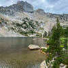
Because you are following the Continental Divide [separation between drainage to the Pacific Ocean (Idaho side) and Atlantic Ocean (Montana side)] you'll always be high in the mountains following the natural elevation changes along the divide and will not ascend or descend into the deep creek and river valleys that boarder the course, except when you drop off the divide to the finish. Because of this, the entire race is at a high elevation with respect to this part of Idaho and Montana. This course has a good mix of terrain, with a mix of climbs, descents, smooth trail and technical sections.
The course is easy to follow. The first time we (the RD's) covered the entire course on a reconnaissance run we did not get lost. The main reason for this is that there exists good official CDT signage. The official signage consists of CDT signs on trees and posts, the "i" mark on trees (note the new and old variations), and rock cairns. On some parts of the course they help mark the trail and the Continental Divide near the trail. Besides these abundant existing markings, we will use additional yellow flagging to ensure that the course is clearly marked.
Shared By:
Dave Dutro

 Continue with onX Maps
 Continue with Facebook


 Particularly Special Place


 Difficult


0 Comments