Dogs Leashed

Features
Views · Wildlife
Overview
This is a unique opportunity to see the earth in action by running La Soufrerie Volcano, an active volcano that will let you feel the heat though your shoes. Do not hesitate on taking this breathtaking challenge!
Description
The elevation of the volcano is 1.234 m. The run begins with a stretch of trail by the beach, until you get to the "entrance" of the trail of the volcano.
The run takes about 3-4 hours to get the top of the volcano and then 3-4 hours to go back.
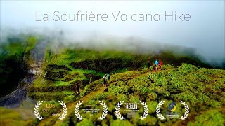
On the way to the volcano, you'll be able to have wonderful and scenic views full of green colors and the sea as the background. Also in the way to the top, signs with the flora and fauna descriptions can be found in the resting stops.
By the time you get to the top, you'll be able to feel the heated earth though your feet and see the magnificent crater in the middle. If you like, there is the possibility to go to the crater and feel the earth in action by feeling the warm environment.
The run is wonderful and breathtaking because of the landscapes, the views, and the feeling of being in the center of the action.
History & Background
La Soufrière is an active volcano, the highest peak on Saint Vincent as well as the highest point in the island. The Volcano has erupted in 1718, 1812, 1902, 1971, and 1979. The trail to the Volcano from the Leward side was destroyed due to the heavy rains some years ago. In 2016, international and local non-profits in conjunction with the government make a big effort to put the trail back where it was. After some months of intense work, the trail was restored with new flora and fauna signs and new rest stops.
Shared By:
Richmond Vale Diving and Hiki…

 Continue with onX Maps
 Sign in with Facebook


 Particularly Special Place


 Intermediate


0 Comments