
 Continue with onX Maps
 Continue with Facebook


 Particularly Special Place


 Difficult
Difficult
Difficult
 Difficult
Land Manager: BLM Colorado - Royal Gorge Field Office
 Columbine - Bear Creek Loop
8.5 mi 13.7 km • 1,542' Up 469.9 m Up • 1,543' Down 470.2 m Down
 Salida, CO
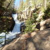
 Browns Creek Falls
5.8 mi 9.4 km • 967' Up 294.83 m Up • 968' Down 295.07 m Down
Alpine, CO
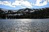
Waterdog Lakes
4.2 mi 6.7 km • 1,107' Up 337.48 m Up • 1,110' Down 338.29 m Down
Whitepine, CO
 High Lonesome 100 Mile Trail Race
102.0 mi 164.2 km • 21,057' Up 6418.14 m Up • 21,057' Down 6418.27 m Down
Alpine, CO
Breakfast Meats Loop
6.4 mi 10.3 km • 495' Up 150.94 m Up • 494' Down 150.51 m Down
Buena V…, CO
Mount Antero
14.7 mi 23.7 km • 4,748' Up 1447.07 m Up • 4,746' Down 1446.69 m Down


0 Comments