
 Continue with onX Maps
 Continue with Facebook


 Particularly Special Place


 Intermediate

 Intermediate
Land Manager: USFS - Caribou & Targhee National Forests Office
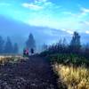
 Kelly Mountain Loop
5.3 mi 8.5 km • 745' Up 227.21 m Up • 744' Down 226.81 m Down
 Rigby, ID
 Gnarly Bear 25k/50k Race Course
16.3 mi 26.3 km • 2,903' Up 884.7 m Up • 2,904' Down 885.27 m Down
Rigby, ID
 Cress Creek Nature Trail
1.3 mi 2.0 km • 287' Up 87.45 m Up • 288' Down 87.71 m Down
Upper Palisades Lake
14.4 mi 23.1 km • 1,726' Up 526.16 m Up • 1,726' Down 526.21 m Down
Irwin, ID
Teton Crest Trail
73.7 mi 118.6 km • 9,953' Up 3033.77 m Up • 9,468' Down 2885.86 m Down
Moose W…, WY
Mt. Baird Out and Back
9.2 mi 14.9 km • 3,934' Up 1198.94 m Up • 3,933' Down 1198.76 m Down
Victor, ID


0 Comments