
 Continue with onX Maps
 Continue with Facebook


 Particularly Special Place


 Intermediate
Intermediate
Intermediate
 Intermediate
Land Manager: OC Parks - Laguna Coast Wilderness Park
 Laurel Canyon Loop
3.7 mi 5.9 km • 607' Up 184.88 m Up • 606' Down 184.81 m Down

 Aliso Creek Park Loop
10.0 mi 16.0 km • 820' Up 249.82 m Up • 820' Down 249.87 m Down
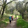
Trabuco Creek Out-and-Back
14.5 mi 23.4 km • 1,074' Up 327.5 m Up • 1,075' Down 327.53 m Down
 Peter's Canyon Loop
5.4 mi 8.6 km • 419' Up 127.76 m Up • 418' Down 127.38 m Down
O'Neill Park Loop Vista Trail
3.7 mi 6.0 km • 668' Up 203.7 m Up • 668' Down 203.57 m Down
Rancho…, CA
 Mountains to Sea Trail
20.3 mi 32.6 km • 192' Up 58.37 m Up • 740' Down 225.53 m Down


0 Comments