
 Continue with onX Maps
 Continue with Facebook


 Particularly Special Place


 Intermediate
Intermediate
Intermediate
 Intermediate
Land Manager: Maryland Department of Natural Resources
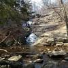
 Cunningham Falls Out-and-Back
1.2 mi 2.0 km • 142' Up 43.4 m Up • 142' Down 43.29 m Down


 Catoctin 50k
34.0 mi 54.6 km • 5,507' Up 1678.55 m Up • 5,510' Down 1679.48 m Down
Braddoc…, MD
Battlefield Forest Creek Loop
2.9 mi 4.6 km • 104' Up 31.83 m Up • 123' Down 37.49 m Down
 Sugarloaf Loop
7.6 mi 12.3 km • 1,180' Up 359.67 m Up • 1,187' Down 361.65 m Down
Clarksburg, MD
 Timber Ridge/Tobacco Barn to Pine Grove Loop
5.4 mi 8.7 km • 483' Up 147.14 m Up • 481' Down 146.76 m Down
Loudoun Heights Out and Back
6.3 mi 10.1 km • 1,204' Up 366.98 m Up • 1,204' Down 366.93 m Down


0 Comments