
 Continue with onX Maps
 Continue with Facebook


 Particularly Special Place


 Intermediate/Difficult
Intermediate/Difficult
Intermediate/Difficult
 Intermediate/Difficult
 Slate Canyon/Rock Canyon Loop
11.2 mi 18.1 km • 3,442' Up 1049.18 m Up • 3,441' Down 1048.75 m Down


 Stewart Cascades Trail #056
3.6 mi 5.9 km • 680' Up 207.3 m Up • 680' Down 207.27 m Down
Cedar H…, UT
Mount Timpanogos Loop
14.9 mi 24.0 km • 4,856' Up 1480.25 m Up • 4,845' Down 1476.64 m Down
Cedar H…, UT
 Alta-Brighton Loop
8.6 mi 13.8 km • 2,297' Up 700.24 m Up • 2,319' Down 706.93 m Down
Alta, UT
Pfeifferhorn
9.6 mi 15.5 km • 3,596' Up 1095.95 m Up • 3,595' Down 1095.87 m Down
Alta, UT
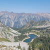
Brighton Lakes to Sunset Peak
6.1 mi 9.9 km • 1,837' Up 559.87 m Up • 1,833' Down 558.78 m Down
Brighton, UT


0 Comments