
 Continue with onX Maps
 Continue with Facebook


 Particularly Special Place


 Intermediate

 Intermediate
Land Manager: National Park Service - Great Falls National Park
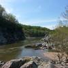
 Great Falls Park - South Loop
3.3 mi 5.3 km • 201' Up 61.16 m Up • 203' Down 61.8 m Down
 Great F…, VA
Billy Goat Trail C Loop
Great F…, VA
Billy Goat Trail C Loop
2.9 mi 4.6 km • 140' Up 42.52 m Up • 139' Down 42.28 m Down
Cabin John, MD
 Chesapeake and Ohio Canal Loop
1.6 mi 2.6 km • 51' Up 15.42 m Up • 50' Down 15.39 m Down
Potomac, MD
Riverbend-Great Falls
3.8 mi 6.2 km • 225' Up 68.62 m Up • 215' Down 65.66 m Down
Rock Creek Valley Loop
1.3 mi 2.1 km • 35' Up 10.78 m Up • 35' Down 10.76 m Down
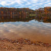
 Lake Shore Trail
3.3 mi 5.4 km • 114' Up 34.79 m Up • 113' Down 34.46 m Down
Gaither…, MD


0 Comments