 Race - Mar 7, 2020
Dogs Unknown

Features
River/Creek · Views · Wildlife
Overview
Located near Sonoita in the Santa Rita Mountains, this challenging 25 mile loop is the route of the Old Pueblo 50 Miler for 2016. This is the newly redesigned course layout which will be run twice to make the total mileage of the course. Course conditions will vary throughout the year, especially as this run varies between about 5,000 ft. up to over 6,200 ft. of elevation.
Description
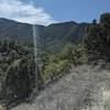
Heading out from Kentucky Camp, the course begins with a hill climb up to the road and turns left with a gorgeous view of Mt. Wrightson in the distance. This steady ascent continues up the jeep road, gaining about 400 feet in the first 2.5 miles. A quick downhill section where you drop a hundred feet follows, with another 300+ foot gain in just over 1 mile. It's in this section of climb where the course heads off the jeep road and onto a singletrack section of the Arizona Trail. After topping out, you'll be greeted with some inspiring views above the valley floor as you descend rapidly on the rock-strewn trail for about 1.5 miles.
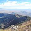
From here, it's pretty much all uphill to the Melendrez Aid Station at mile 9. This first aid station will be a welcome relief 9 miles into the race and a good spot to regroup before heading up one of the most challenging sections of the course. Immediately upon leaving the aid station, you'll climb up, up, up a steep singletrack section before navigating a perilously narrow ridgeline trail at what is the peak elevation of the entire course. When it's covered in snow, as was the case when run in Februray, the drop off to your left will be intimidating for some. This section of the Arizona Trail was also fairly overgrown, so wearing longer pants would be recommended to avoid having bloody legs. Heading down from this ridgeline, you'll encounter more rocky trail conditions that makes for a moderately technical gradual descent that leads into a beautiful forest, complete with some stream crossings.
Much of the next 7 miles is run on dirt and rock covered forest service roads. There are many segments here that are easily run, but they're also interrupted by some quite steep uphill grades on the first couple miles of road. A prolonged downhill section of moderate steepness signals the Cave Creek Aid Station is nearing at mile 15. After one last creek crossing and short hill the aid station is reached.
It's here where a 650 foot climb begins over the next 3 miles. The first couple miles of this climb are up a forest service road that seemingly never ends as you ascend this seemingly gradual slope. The only positive about this slog of a climb is that Mt. Wrightson provides for some beautiful scenery as you march closer to its base. Mercifully, the road does have an end but the climbing doesn't stop as you head up the link trail to an elevation of just under 6,000 feet at the turnaround point. From here you descend again, down the another forest service road, crossing multiple creeks on your way down before hitting a gorgeous section of singletrack Arizona Trail on the left. With, by far, the smoothest running conditions of the day your feet will rejoice in this faster section. Finally you'll drop down off of the hillside and meet back up with the road at the Gardner Canyon Aid Station at mile 21.
With seemingly only 4 more miles back to Kentucky Camp, your spirits are likely to be high. A little singletrack section welcomes you upon leaving the Gardner Canyon Aid Station, a few slopes are thrown in for good measure, including one last ridgetop ascent that helps you feel the burn in your legs. Trucking on down another rocky, gently sloping road on top of the ridge, you'll know you're almost home. One last section of singletrack remains as you descend off of the ridge with some fun switchbacks. It's at the end of this downhill where you realize the 4 miles from the Gardner Canyon Aid Station has come and gone and Kentucky Camp in not yet in sight. That realization and a final modest uphill could fracture some nerves as you come into the final stretch of singletrack through grasslands before finally reaching Kentucky Camp. Now, for the Old Pueblo 50, you only have to repeat this whole route one more time to finish the race! Getting motivated to leave Kentucky Camp may prove challenging for some after this journey.
Flora & Fauna
All sorts of wildlife can be spotted in the Santa Ritas. This includes everything from wild turkeys, deer, bears, mountain lion, and there is even a jaguar somewhere in the wilderness here.
Contacts
Shared By:
Stephen Woodall

 Continue with onX Maps
 Continue with Facebook


 Particularly Special Place


 Difficult

 Florida Canyon Trail #145

 Josephine Saddle via Super Trail
 Arivaca…, AZ
 Rincon Peak


0 Comments