
 Continue with onX Maps
 Continue with Facebook


 Particularly Special Place


 Intermediate
Intermediate
Intermediate
 Intermediate
Land Manager: USFS - Dakota Prairie Grasslands
 Painted Canyon Nature Trail
1.1 mi 1.8 km • 262' Up 79.71 m Up • 261' Down 79.66 m Down

 Medora, ND
Jones/Lower Talkington/Lower Paddock Loop
Medora, ND
Jones/Lower Talkington/Lower Paddock Loop
11.8 mi 19.0 km • 509' Up 155.16 m Up • 507' Down 154.68 m Down
Medora, ND
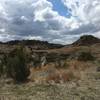
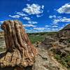
Petrified Trail Loop
10.6 mi 17.1 km • 601' Up 183.11 m Up • 592' Down 180.39 m Down
Medora, ND


0 Comments