
 Continue with onX Maps
 Continue with Facebook


 Particularly Special Place


 Intermediate/Difficult
Intermediate/Difficult
Intermediate/Difficult
 Intermediate/Difficult
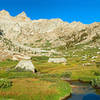
 Rae Lakes Loop
40.4 mi 65.0 km • 7,007' Up 2135.69 m Up • 7,007' Down 2135.68 m Down
 Squaw V…, CA
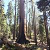
 Congress Trail
1.9 mi 3.0 km • 350' Up 106.6 m Up • 314' Down 95.62 m Down
 Three R…, CA
Mineral King Loop
Three R…, CA
Mineral King Loop
25.6 mi 41.3 km • 9,101' Up 2773.89 m Up • 9,091' Down 2771.03 m Down
Three R…, CA
 Redwood Mountain Grove: Hart Trail & Sugar Bowl Trail Loops
9.9 mi 16.0 km • 1,929' Up 587.85 m Up • 1,912' Down 582.87 m Down
Three R…, CA
Giant Forest Loop Trail
7.5 mi 12.0 km • 972' Up 296.24 m Up • 952' Down 290.23 m Down
Three R…, CA
Dead Giant Loop via Sunset Trail
1.8 mi 2.9 km • 315' Up 95.89 m Up • 312' Down 95.21 m Down
Squaw V…, CA


0 Comments