
 Continue with onX Maps
 Continue with Facebook


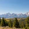
 Particularly Special Place


 Intermediate
Intermediate
Intermediate
 Intermediate
Land Manager: National Park Service - Grand Teton National Park
 Hermitage Point
10.2 mi 16.4 km • 438' Up 133.55 m Up • 430' Down 131 m Down

 Yellows…, WY
 Grand View Point
1.7 mi 2.8 km • 531' Up 161.79 m Up • 530' Down 161.51 m Down
Yellows…, WY
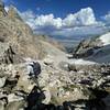
 Lupine Meadows to Lower Saddle
13.5 mi 21.7 km • 4,929' Up 1502.4 m Up • 4,929' Down 1502.39 m Down
Alta, WY
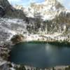
 Amphitheater Lake
9.9 mi 16.0 km • 2,949' Up 898.84 m Up • 2,949' Down 898.79 m Down
Jackson, WY
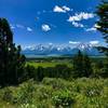
Emma Matilda Lake
10.2 mi 16.5 km • 714' Up 217.48 m Up • 708' Down 215.73 m Down
Death Canyon & Static Peak Divide to Teton Canyon
19.6 mi 31.6 km • 4,383' Up 1335.98 m Up • 4,231' Down 1289.52 m Down
Moose W…, WY


0 Comments